Projects / Mapping the invisible: rock-wall permafrost in Greenland
Mapping the invisible: rock-wall permafrost in Greenland
Integrated field measurement, geophysical characterization, and heat conduction modelling of permafrost in exposed bedrock around Sisimiut and Disko Bay. Climate scenario projections to 2100.
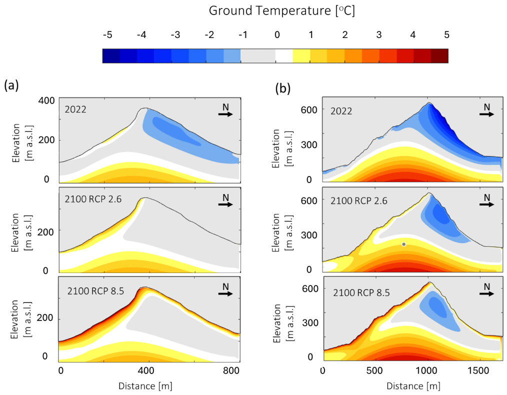
Mean Rock Surface Temperature (MRST) modelled across the Sisimiut mountain area for three periods: present (2002-2022) and end-of-century (2080-2100) under RCP2.6 and RCP8.5. Switch scenarios from the layer panel to compare. Ground Surface Temperature (RST) logger pins (2019-2024) are clickable for the observed daily temperature time series; multiple loggers can be compared.
Context: permafrost hazards in Arctic terrain
Rock-wall permafrost in Arctic mountain terrain is a driver of rockfall and slope instability. In Greenland, where growing communities increasingly interact with steep fjord walls and where climate change is amplified relative to lower latitudes, understanding the thermal state of permafrost in exposed bedrock is directly relevant to infrastructure safety and territorial planning. .
Study site and field programme
This work focused on the mountains surrounding Sisimiut (68°N on the west coast), the second-largest city in Greenland and located in an typical mountain arctic environment. Growing development pressure and documented landslide activity made the region a natural focus for permafrost hazard assessment, although no data was available regarding bedrock permafrost conditions.
Beginning in autumn 2020, nine ground surface temperature (RST) loggers were installed across the study area, covering the local range of elevations and slope aspects. Two deep boreholes (100 m) were drilled in lowland flat bedrock to provide calibration data. Vertical electrical resistivity tomography profiles were acquired on exposed rock faces at multiple sites to delineate frozen and unfrozen ground.
Fieldwork campaign on Disko Island, spring 2023, deploying ERT electrode arrays and thermistor strings for rock-wall permafrost characterization.
Modeling approach and climate projections
A statistical model was trained on measured rock surface temperatures to map potential permafrost disitritbution. This empirical coupling was then applied to weather data spanning 1870-2022 to generate high-resolution RST boundary conditions for transient heat transfer simulations in complex topographies. The model was calibrated against deep borehole records and validated against ERT-derived frozen/unfrozen boundaries.
Regional carbon pathway scenarios RCP2.6 (moderate) and RCP8.5 (high-emissions) were used to force the model forward to 2100. Results mapped the thermal vulnerability of this region to ongoing climate change.
Related projects
This work integrates data and insights from various research projects across Greenland: TEMPRA, Siku Aajuitsoq, Thawing Moutains and GeoZack Together, these projects form an integrated framework for understanding permafrost distribution and hazard potential across the region.
Fieldwork photographs
Publications
Modelling present and future rock wall permafrost distribution in the Sisimiut mountain area, West Greenland
Marcer, Duvillard, Tomaskovicova, Nielsen, Revil, Ingeman-Nielsen · The Cryosphere · 18, 1753-1771 · 2024
doi:10.5194/tc-18-1753-2024Widespread rock wall permafrost degradation in Greenland and its relation to atmospheric warming
Marcer, Duvillard, Ravanel, Nielsen, Ingeman-Nielsen · submitted to The Cryosphere
Dataset: Bedrock Permafrost in Sisimiut, West Greenland
Ground temperature records, ERT profiles, and model outputs
DTU Data